
ENTERPRISE EXISTING CONDITIONS DOCUMENTATION
Office As-Built Survey Services for Accurate Existing-Condition Documentation
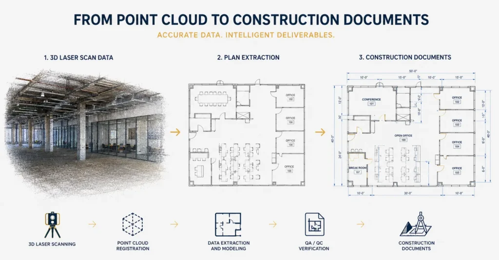
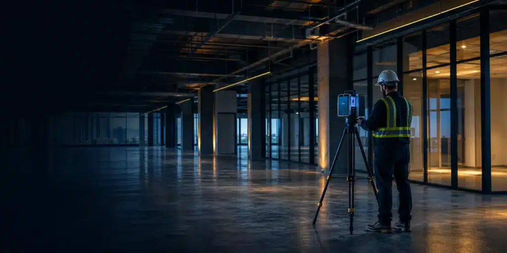
Reality IMT provides office as-built survey services that deliver highly accurate documentation of office buildings and commercial spaces. Using advanced 3D laser scanning and reality capture technologies, we create floor plans, elevations, BIM-ready models, and existing-condition documentation that support leasing, renovations, tenant improvements, facility management, and capital planning projects.
What This Service Includes
Our office as-built surveys capture far more than basic square footage measurements. We document walls, structural elements, doors, windows, MEP systems, ceiling conditions, and architectural features to create a complete digital representation of existing office environments. The resulting documentation supports leasing compliance, renovation planning, tenant improvements, space utilization studies, and facility management initiatives.
Who Uses This Service
Architects & Engineers
Existing-condition documentation for office renovations, tenant improvements, interior design, and construction planning.
Owners & Facility Teams
Space management, leasing documentation, facility planning, capital improvements, and asset management.
Contractors
Accurate field measurements for estimating, coordination, renovation planning, and construction execution.
Industrial / CRE / Public Sector
Commercial office owners, property managers, corporate facilities, business campuses, and government office buildings.
Common Use Cases
Tenant Improvement Planning
Document existing office layouts before renovations, expansions, or tenant build-outs.
BOMA Area Verification
Generate accurate measurements supporting rentable area calculations and leasing compliance.
BIM & CAD Documentation
Create reliable as-built documentation for design teams, consultants, and facility managers.
Deliverables
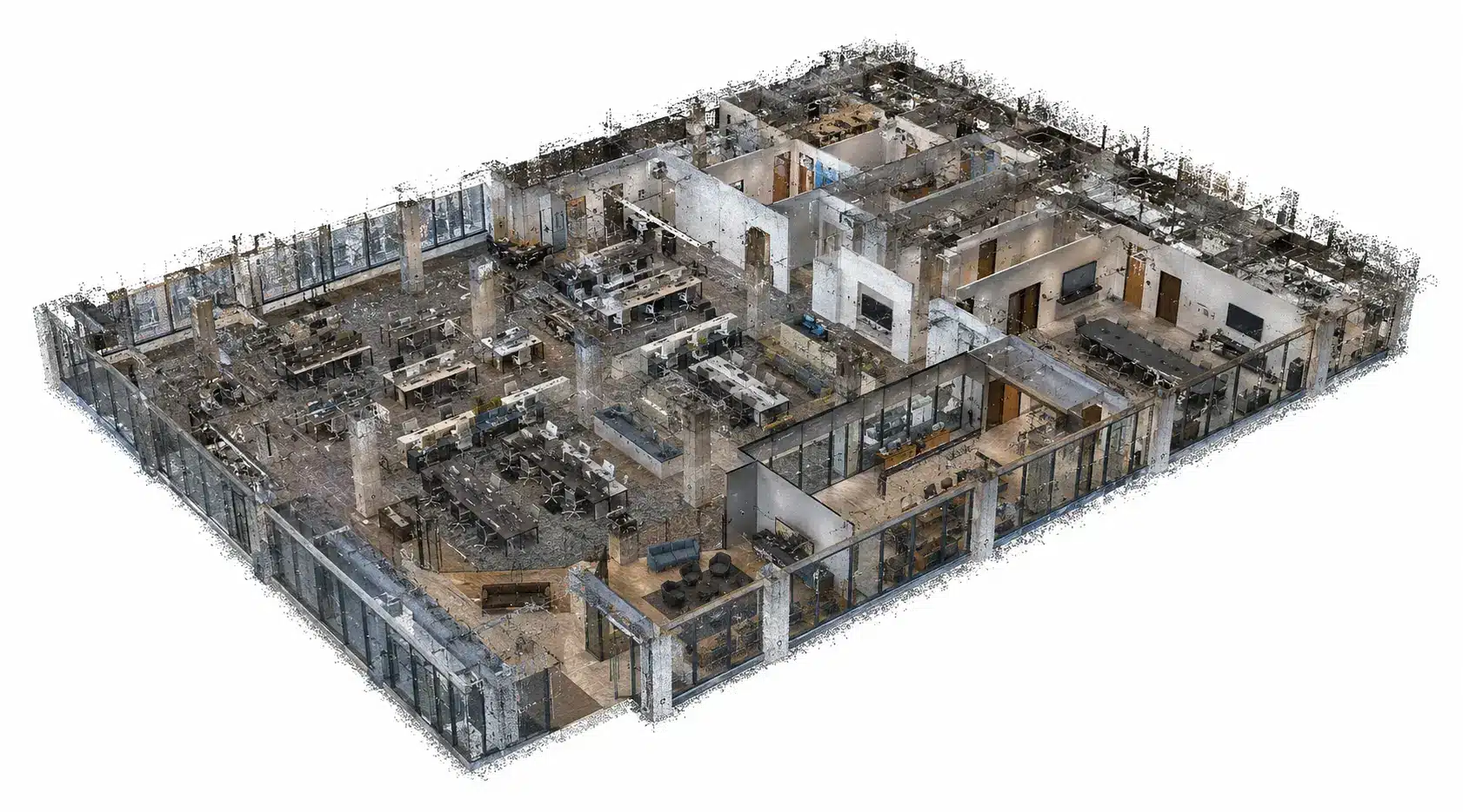
Point Cloud
High-accuracy point cloud data used for measurements, coordination, verification, and future reference.
CAD / DWG Drawings
Floor plans, reflected ceiling plans, elevations, and detailed office documentation.
Revit / BIM Model
BIM-ready office models supporting renovations, facility management, and design coordination.
Floor Plans / Reports
Office layouts, area calculations, existing-condition documentation, and reporting deliverables.
360 Visual References
High-resolution panoramic imagery supporting virtual site review and facility planning.
Our Process
Scope
Review building access requirements, project objectives, deliverables, schedule, and occupancy considerations.
Capture & Process
Perform laser scanning and field measurements, then process data into drawings, reports, BIM models, and approved deliverables.
Deliver
Provide floor plans, BIM models, point clouds, elevations, reports, and supporting documentation.
Related Services
Building Documentation & Floor Plans
Accurate measurement and documentation of commercial buildings and facilities.
As-Built Drawings & CAD
Existing-condition CAD documentation for renovation and facility planning projects.
3D Laser Scanning
Reality capture and high-accuracy data collection for office environments.
FAQs
What is an office as-built survey?
An office as-built survey documents the existing layout and physical conditions of an office space, including walls, ceilings, structural elements, and building systems.
Why are office as-built surveys important?
They provide accurate existing-condition information for renovations, tenant improvements, leasing, facility management, and construction planning.
What is BOMA compliance?
BOMA standards establish methods for measuring rentable and usable areas in commercial office buildings, helping owners and tenants maintain consistent space calculations.
What deliverables are available?
Floor plans, elevations, reflected ceiling plans, BIM models, point clouds, reports, and panoramic imagery.
Can occupied office spaces be surveyed?
Yes. Surveys can be performed while minimizing disruption to daily operations and tenant activities.
Are BIM models available?
Yes. Deliverables can include Revit and BIM-ready models for design, coordination, and facility management.
How accurate are the measurements?
Reality IMT uses professional laser scanning equipment capable of capturing highly accurate building measurements.
Can the data support tenant improvement projects?
Yes. Office as-built surveys are commonly used as the foundation for tenant improvement design and construction.
How long does an office as-built project take?
Project timelines depend on building size, complexity, occupancy conditions, and required deliverables.
What information is needed for a quote?
Project location, building size, occupancy conditions, desired deliverables, and project schedule.
Need accurate office as-built documentation for your project?
Send your building location, approximate square footage, occupancy conditions, and deliverable requirements. We’ll recommend the right office surveying and documentation solution.